U.S.
Hurricane Helene could bring "catastrophic and deadly storm surge" to parts of Florida Gulf Coast
By Alex Sundby, Jason Allen, David Yeomans
Updated on: September 26, 2024 / 5:10 AM EDT / CBS News
Hurricane Helene is strengthening as it moves across the eastern Gulf of Mexico toward a forecast Thursday evening or early Friday morning landfall over Florida's Big Bend Coast and is "expected to bring catastrophic winds and storm surge to the northeastern Gulf Coast," the National Hurricane Center said early Thursday. "Preparations to protect life and property should be rushed to completion," the center urged.
The National Weather Service warned in a post on X that, "A catastrophic and deadly storm surge is likely along portions of the Florida Big Bend coast, where inundation could reach as high as 20 feet above ground level, along with destructive waves. There is also a danger of life-threatening storm surge along the remainder of the west coast of the Florida Peninsula. Residents in those areas should follow advice given by local officials and evacuate if told to do so."
Helene had maximum sustained winds of 90 mph overnight Thursday, making it a Category 1 storm. Winds of 96-110 mph would make it a Category 2 and it would be classified as a Category 3 -- and major hurricane -- with winds of 111-129 mph.
The Hurricane Center said, "Strengthening is forecast, and Helene is expected to be a major hurricane when it reaches the Florida Big Bend coast this evening."
After landfall, Helene "is expected to turn northwestward and slow down over the Tennessee Valley on Friday and Saturday," the center noted.
"Weakening is expected after landfall, but Helene's fast forward speed will allow strong, damaging winds, especially in gusts, to penetrate well inland across the southeastern United States, including over the higher terrain of the southern Appalachians," the center said.
Rain could also be a big issue.
"Over portions of the Southeastern U.S. into the Southern Appalachians, Helene is expected to produce total rain accumulations of 6 to 12 inches with isolated totals around 18 inches," the hurricane center said. "This rainfall will likely result in catastrophic and potentially life-threatening flash and urban flooding, along with significant river flooding. Numerous landslides are expected in steep terrain across the southern Appalachians."
Helene is a very large storm. Hurricane-force winds were extending outward up to 60 miles from its center and tropical-storm-force winds were extending outward up to 345 miles, the center said.
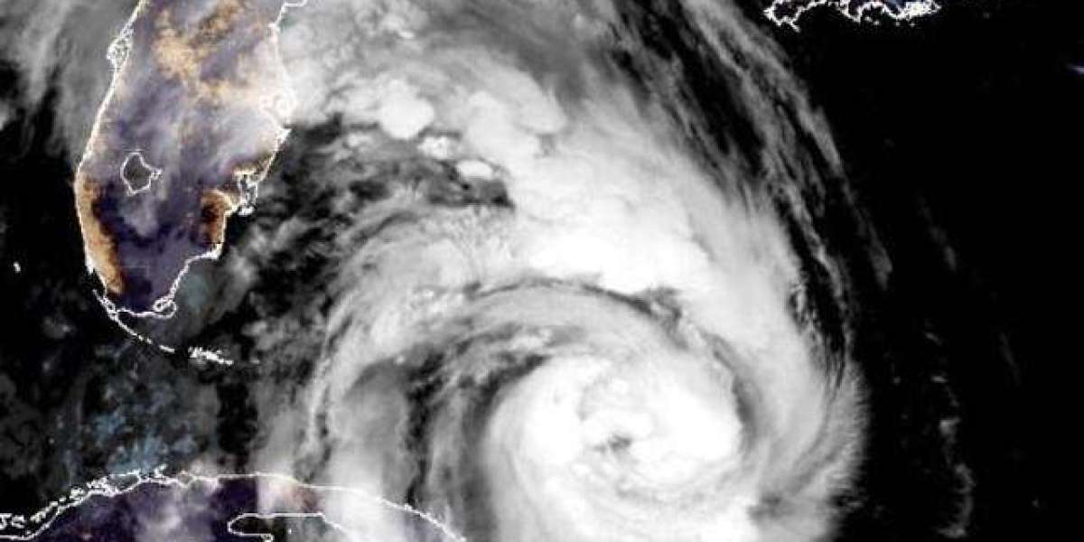
hurricane-helene-251a-092624.jpg
Mammoth Hurricane Helene as seen from a satellite over the Gulf of Mexico early on Sept. 26, 2024.
NOAA / National Hurricane Center
In a Category 3 storm, well-built framed homes in the hardest-hit coastline communities may incur major damage or removal of roof decking, the hurricane center said. Many trees will be snapped or uprooted, blocking roadways. Electricity and water will likely be unavailable for several days to even weeks after the storm passes.
Florida Gov. Ron DeSantis told reporters Wednesday that thousands of lineworkers were coming to the state to restore power after the storm passes.
"It is anticipated that there is going to be power outages, so folks have an opportunity to plan for that now," DeSantis said. "You still have time to make the preparations and put your plan in place today, but that time is running out."
In Florida's Big Bend area south of Tallahassee, from Carrabelle to the Suwannee River, forecasters expected the water to reach 15-20 feet above ground if the storm surge's peak occurred at the same time as high tide. Other areas could see anywhere from 3-15 feet of water, the hurricane center warned.
"The water impacts are probably going to be the most impactful part of the storm, the most deadly part of the storm," Jamie Rhome, a deputy director at the hurricane center, told CBS News.
Watches and warnings were issued throughout Florida ahead of the storm.
President Biden and DeSantis declared emergencies in the state earlier in the week, and evacuation orders were issued in several counties. At the University of Tampa, officials were trying to evacuate all residential students by Wednesday afternoon.
DeSantis discouraged Floridians from traveling hundreds of miles from their homes to flee the storm because Helene was expected to move inland after making landfall. He instead urged people to move to higher ground in their own area by going to a friend or family member's home or to a shelter.
States of emergency were also declared in Georgia, North and South Carolina and as far north as Virginia.
Florida preparing for Hurricane Helene
Along Florida's west coast, residents were preparing for the storm by boarding up windows, fueling up their vehicles and filling up sandbags before Helene's potentially dangerous hit.
In Tallahassee, Dorothy Richardson was getting ready to hunker down with six of her grandchildren.
"Either which way it go, I need to prepare," Richardson said. "Getting my sandbags … got my coal, got my lighter fluid, got my propane tank."
People fill up sandbags at Joe DiMaggio Sports Complex before Helene's expected landfall on Florida's Big Bend, in Clearwater, Florida, Sept. 25, 2024.
People fill up sandbags at Joe DiMaggio Sports Complex before Helene's expected landfall on Florida's Big Bend, in Clearwater, Florida, Sept. 25, 2024.
Reuters/Marco Bello
Russell King was preparing to evacuate his Mexico Beach home. He said the house barely withstood Hurricane Michael in 2018.
"We lost our shower, we lost our elevator, we lost all of our ground floor walls," King said. "We think we're OK with these now, but, you know, we don't know — 125 miles an hour, they get blown out."
Tallahassee Mayor John Dailey said the city is doubling its workforce with crews from other states coming in to help restore power and deliver aid to the area after Helene hits.
"It's very concerning," Dailey said. "I'm from Tallahassee, this is my hometown. We have never seen a storm of this magnitude that could possibly be a direct hit to Tallahassee."
Farther south, in Tampa, a makeshift wall was installed outside Tampa General Hospital to keep out water from the nearby bay. The area was expected to see 5-8 feet of storm surge. Officials said the wall held back about 2 1/2 feet of water last year when Hurricane Idalia hit.
Warm water in Gulf fuels hurricane
Record-warm water in the Gulf would act like jet fuel in intensifying the storm. Brian McNoldy, senior research associate at the University of Miami Rosenstiel School of Marine, Atmospheric, and Earth Science, recently noted that ocean heat content in the Gulf of Mexico is the highest on record. Warm water is a necessary ingredient to strengthen tropical systems.
Sea surface temperatures in the path of Helene are as warm as 89 degrees Fahrenheit — 2 to 4 degrees F above normal. These record water temperatures have been made significantly more likely by human-caused climate change, according to Climate Central. The North Atlantic Ocean as a whole has seen record warm temperatures in 2024, storing 90% of the excess heat from climate change produced by greenhouse gas pollution.